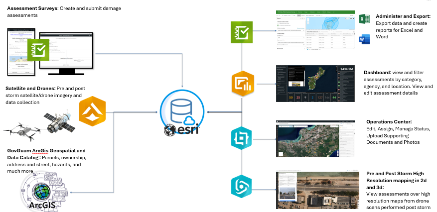
Map, Service and Geodatabase include layers for property boundaries (with tax and ownership), Locations, POIs, roads, addresses, Federal Lands (with easements, and licensed property), impervious surfaces, building footprints, 2020 Census, and Hydrology. Map also includes a Historic Base Map from 1944 for historic trails and placenames.

Map, Service and Geodatabase include layers for Hazards. Hazard layers overlay Essential Facilities, Structures, Transportation Systems, and Utilities (unitalities are only available in GovGuam version for certain agencies). This map was utilized to perform the hazard impact analysis and impact estimates in the 2024 Hazard Mitigation Plan.
This web map presents the inventory of parcels suitable for the Guam Forest System Plan The GFSP parcels was created in close collaboration with the Department of Land Management (DLM).
Website Restoration Update
As part of a recent global cyber incident targeting cPanel-hosted servers, bsp.guam.gov was among the millions of domains compromised worldwide. Unfortunately most file downloads and embedded content hosted with the site could not be restored.
The Bureau of Statistics and Plans is currently restoring our site and securely re-uploading all files, data sets, and media—including vital public materials and reports e.g. for the Guahan 2050 Sustainability Plan—that were linked prior to the attack.
We anticipate the full restoration of the website to be completed in a months time. More recently published files will be prioritized and will be available in a shorter time frame. We appreciate your patience and understanding as we work toward full restoration of BSP’s extensive digital repository of reports, plans, and data.